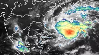
Cyclone Jawad: Odisha, Andhra Pradesh on high alert
text_fieldsThe Indian Meteorological Department has intensified warnings of heavy rain and high winds as Cyclone Jawad is expected to make landfall on Saturday morning on the coast of Odisha. The storm was born of a deep depression in the Bay of Bengal that intensified into a cyclone on Friday afternoon. Alerts related to heavy rain and high wind speed have been issued for Andhra Pradesh, Odisha and the Gangetic Plains of West Bengal as well some northeastern states.
Some models have estimated that the cyclone will move along the coast instead of directly making landfall. The INCOIS report suggests that the cyclone will weaken into a depression around the coast of Puri, in Odisha while moving to make landfall in West Bengal.
Wind speeds are expected to lash Andhra Pradesh and Odisha in particular with estimates of around to 7–80 kmph gusting to 90 kmph by Saturday evening. As Cyclone Jawad moves north-east, high rainfall is predicted for Odisha and isolated parts of West Bengal.
The Meteorological department has predicted heavy to very heavy rainfall at a few places with isolated extremely heavy falls (more than 20 cm) over Odisha's Gajapati, Ganjam, Jagatsinghpur districts on Saturday. Heavy to very heavy rainfall is expected over Koraput, Rayagada, Kandhamal, Nayagarh, Khordha, Cuttack, and Kendrapara.
A red alert for Visakhapatnam, Srikakulam and Vizianagaram in view of heavy rainfall along with high wind speed, as well as isolated extremely heavy rainfall which is likely over north coastal Andhra Pradesh.


