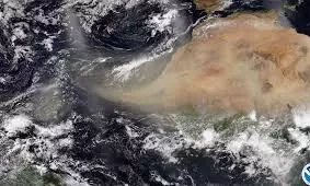
Massive Saharan dust cloud heads to Florida, threatens hurricane season
text_fieldsA significant plume of Saharan dust, the largest observed during the 2024 hurricane season, is making its way across the Atlantic Ocean and is expected to reach the Gulf of Mexico and Florida by the end of the week.
Forecasters predict that this dust cloud could significantly impact storm formation.
The Saharan Air Layer (SAL), which carries dry, dusty air, is known for its ability to absorb moisture, a critical component for the development of tropical storms and hurricanes. Experts suggest that this dust plume will likely suppress storm formation as it travels from Africa towards the Caribbean and possibly Florida.
While this might be good news for those hoping for a quieter storm season, meteorologists warn that the SAL's effects are only temporary. These dust plumes commonly appear in the Atlantic basin during late June and early July, with their influence usually diminishing by mid-to-late July.
The Sahara Desert, spanning an impressive 3.5 million square miles across Africa, serves as a major dust source. The National Oceanic and Atmospheric Administration (NOAA) identifies this dust as the Saharan Air Layer (SAL), which forms during the warmer months, from late spring to early fall. These extensive dust clouds can travel vast distances, affecting regions far from their African origins. The warmth, dryness, and strong winds associated with these dust clouds are known to suppress tropical cyclone formation.
Saharan dust affects weather, climate, and hurricanes in several ways. The extremely dry air weakens storms by promoting downdrafts, while the African Easterly Jet increases wind shear, disrupting storm structures. Additionally, the warm temperatures stabilize the atmosphere, reducing cloud formation. The mineral dust absorbs sunlight, maintaining the warmth of the SAL as it moves across the Atlantic, further inhibiting the development of tropical cyclones.
This latest dust plume's arrival in the Gulf of Mexico and Florida could temporarily dampen storm formation, offering a brief reprieve during the peak of the hurricane season. However, as the influence of the SAL wanes by mid-to-late July, meteorologists urge continued vigilance for potential storm developments.


